
Weston & Sampson , Maryland, USA
Henson Creek Hydraulic Model – Climate Resilient Flood Risk Management
Project Overview
The Henson Creek Hydraulic Model project was designed to simulate flood behavior and hydraulic characteristics of Henson Creek and its six tributaries, incorporating climate resilience and nature-based solutions (NBS) to strengthen water management and infrastructure sustainability.
The model extended the existing HEC-RAS framework, which originally covered 39,252 feet of Henson Creek, by adding 69,830 feet upstream to the I-95 Capital Beltway and four additional tributaries. This expansion provided a comprehensive understanding of hydrological dynamics, enabling improved flood risk management and climate-adaptive infrastructure planning.
Study Components
Integrated Hydraulic Model Development
- Extended the HEC-RAS model to cover 69,830 feet upstream and four tributaries.
- Simulated flood events and water surface profiles to assess flood-prone areas.
- Integrated climate resilience strategies and NBS (wetlands, floodplain buffers) into model design.
Cross-Section and Geometry Setup
- Placed cross-sections every 200 feet using 3-meter DEM and RAS Mapper.
- Aligned cross-sections with natural land features; named sections by distance from creek mouth.
River Bank Station Placement and Adjustments
- Positioned bank stations using steady-state simulations for 2- and 500-year return periods.
- Adjusted stations to improve accuracy in flood modeling and erosion risk management.
Modeling of Culverts, Bridges, and Structures
- Incorporated 33 structures (culverts, bridges) into the model.
- Integrated elevation data from DEM, SWMM, and satellite imagery.
- Simulated structural resilience under extreme weather events.
Energy Losses and Flow Changes
- Adjusted model parameters to accurately estimate energy losses.
- Captured flow changes due to narrowing/widening of channels.
Structural Integration and Flood Resilience
- Modeled culverts, bridges, and embankments to assess impacts on flow dynamics.
- Incorporated NBS such as floodplain buffers and wetlands to enhance resilience.

Deliverables
- Extended HEC-RAS hydraulic model covering 69,830 feet upstream and six tributaries.
- Flood simulations for 2-year and 500-year return periods.
- Cross-section and geometry datasets aligned with DEM and natural features.
- Structural resilience modeling for 33 culverts and bridges.
- Climate-resilient recommendations integrating NBS into floodplain management.
Related Projects
Master Plan for Sustainable Stormwater Drainage Systems in Freetown
Streams Tech, with FMC and Associates, developed Freetown, Sierra Leone’s Stormwater Drainage Master Plan using GIS and modeling to reduce floods and improve infrastructure.

Four Mile Run Watershed Program – SWMM Modeling for Sustainable Stormwater Management
The Four Mile Run program uses an advanced SWMM-based digital twin to manage flooding, assess development impacts, and guide sustainable urban planning in one of Virginia’s most urbanized watersheds

Bacteria TMDL Development for Mattaponi River Watershed
Streams Tech developed TMDLs for 14 impaired Mattaponi River streams, using GIS, HSPF modeling, and data analysis to quantify bacteria loads, propose reduction scenarios, and ensure compliance with water quality standards.

Project Preparation Study on Strengthening Capacity for Livable and Resilient Cities
This study was performed across four critical zones of a megacity to address stormwater challenges. It aimed to design climate-resilient interventions that reduce waterlogging, improve drainage efficiency, and enhance urban livability through integrated planning.
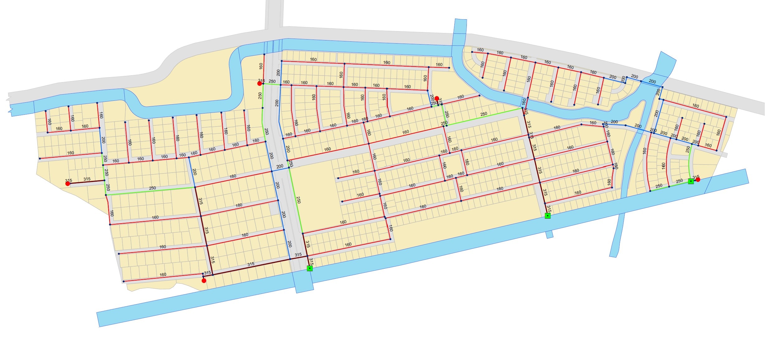
Design of Water Distribution and Storm Drainage Systems for a Private Community
Streams Tech Ltd. designed a comprehensive water distribution and storm drainage system for a urban residential community in Dhaka. The project provided reliable water supply and climate-resilient drainage for approximately 100,000 residents, including 11.8 km of watermains, 5 tube wells, 134 valves, 61 hydrants, and 10.8 km of storm sewers supported by advanced hydraulic and stormwater modeling.
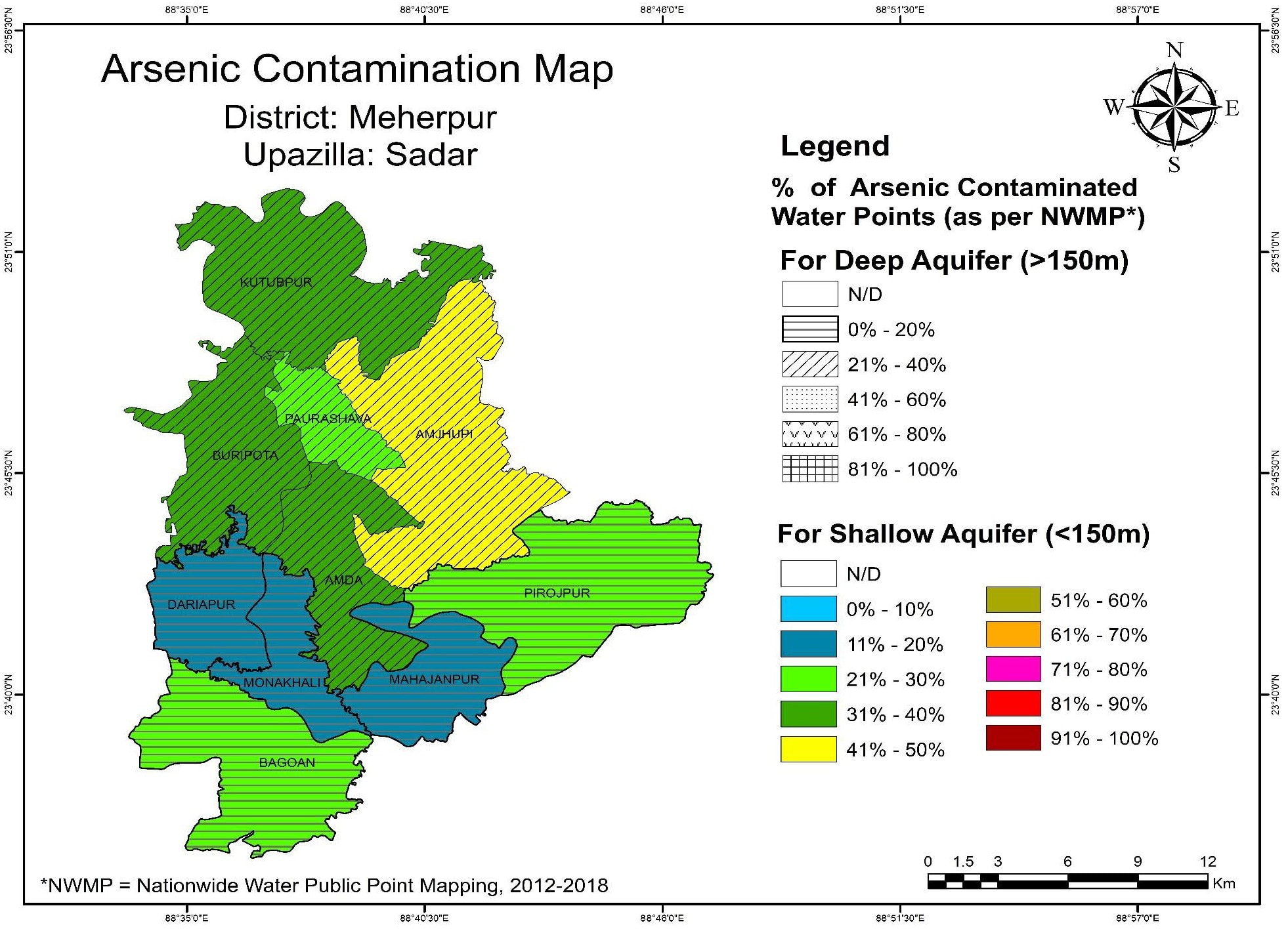
Public Water Supply Technology Mapping for 44 Districts
Streams Tech Ltd. prepared geospatial water technology maps for 44 districts under the Village Water Supply Project, addressing diverse hydrogeological conditions and contamination risks. The project created an inventory of water points, mapped contamination levels, and identified suitable technologies for rural water supply planning.
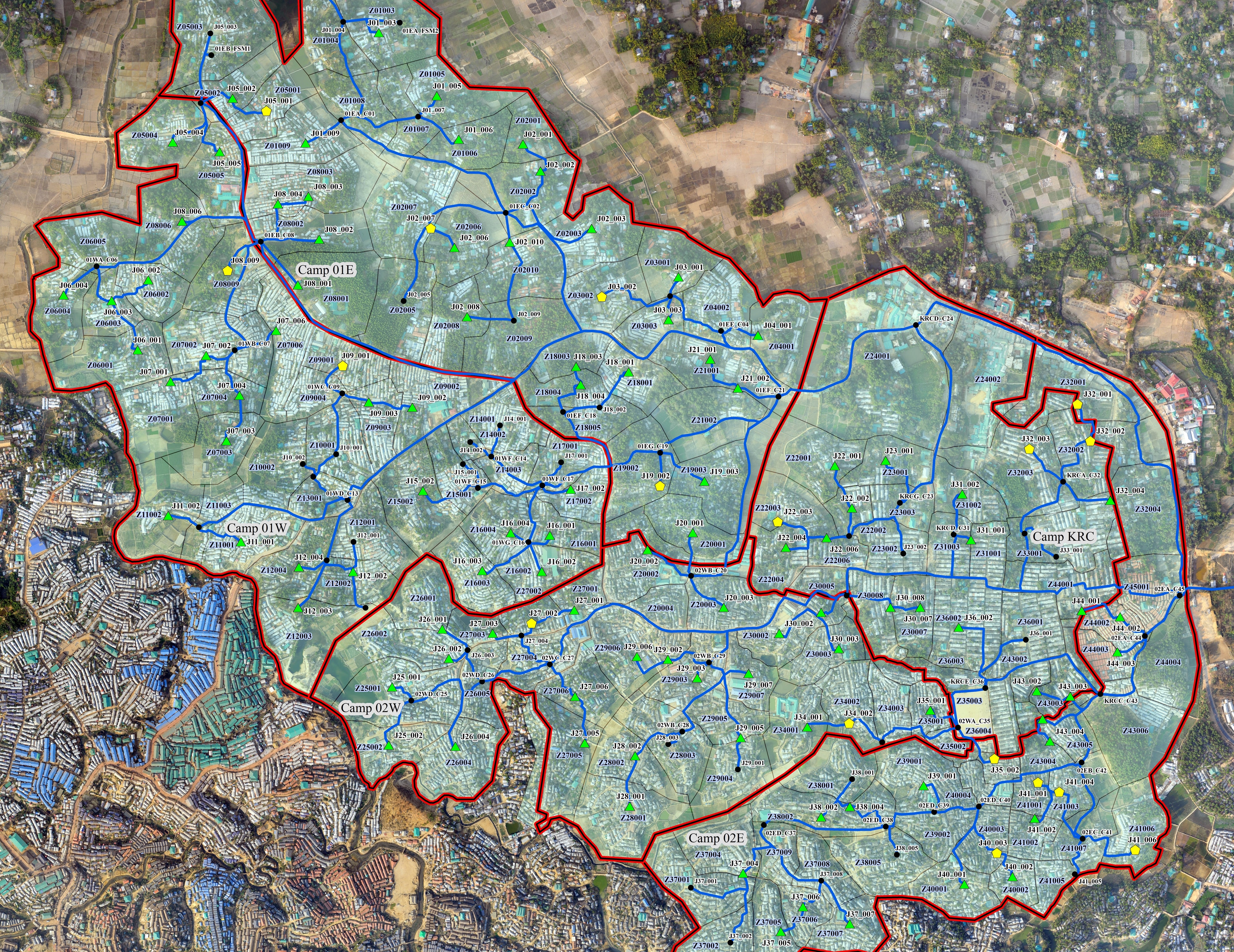
Engineering Design for Sanitation Infrastructure for the Rohingya Refugee Camps
Streams Tech designed three intermediate fecal sludge transfer networks (IFSTN) for Rohingya refugee camps in Cox’s Bazar. The project strengthened sanitation services by creating durable, cost-effective infrastructure for fecal sludge collection, transfer, and treatment, ensuring service sustainability for at least ten years after installation

Planning Sustainable FSM & GWM Systems for Urban Municipalities with the CWIS Approach
Streams Tech conducted a pre-feasibility study in seven towns, mapping maturity for fecal sludge management (FSM) and greywater management (GWM), and City-Wide Inclusive Sanitation (CWIS)-based strategies to strengthen governance and service delivery.

Exploring Hydropower Potential in Southeast Bangladesh
Streams Tech conducted a World Bank-financed hydropower feasibility study in Chattogram, assessing 19 sites along three rivers using hydrologic models and GIS analysis to evaluate generation potential and sustainability.

